H-BIM and GIS for analysis and philological reconstruction of Almonecir castle in Spain
ABSTRACT
The paper explores the potential of Scan-to-BIM procedures, carried out using fast-survey methodologies, for the construction of a representative digital model of historic architecture.
Through its experimentation on a case study, the Castle of Almonecir in the Valencian Community, the research aims to produce an integrated and parametric information system that allows the relation of the fortress with its cultural and historical context. As a result, it will be possible to start a knowledge process of the monument facilitating its understanding and management, with potential tourist applications inside the Valencian area.
Alberto Pettineo, Sandro Parrinello
DIDA, Dept. of Architecture, University of Florence, Italy
Anna Dell’Amico, Francesca Picchio
DICAr, Dept. of Civil Engineering and Architecture, University of Pavia, Italy.
H-BIM models generation with artificial intelligence
ABSTRACT
The data of our cultural heritage obtained through three-dimensional surveys represent complex unstructured geometric structures. The introduction of automatic methods of semantic segmentation and hierarchy between the parts would allow the understanding and use of this data in asset protection operations. In this context, the contribution presents a semi-automatic workflow for the three-dimensional reconstruction of H-BIM models, exploiting a hierarchical classification approach (MLMR) for the optimization of the results.
Lorenzo Ceccarelli
Università di Pisa
Damage survey management: IFC models for historical heritage
ABSTRACT
The paper elaborates an OpenHBIM approach for the digitalisation of the crack pattern in existing buildings, based on Industry Foundation Classes A database is developed, which integrates the collected data, implemented according to standardised classes and properties, and the definition of relationships between entities, enhancing the shared management of information. The interoperability of the tool enables the development of subsequent analytical steps, such as structural modelling of the current state.
Tatiana Zanni, Carlo Zanchetta, Maria Rosa Valluzzi
Università degli Studi di Padova
BHoM & Structural Engineering – A Specialized Approach in Multidisciplinary Projects
ABSTRACT
The challenge of interoperability and the need for algorithmic methodologies in structural engineering require innovative computational workflows now made possible by using the BHoM.
The BHoM is a powerful open-source computational development project supported by Buro Happold.
It allows to improve collaboration on projects, foster standardization and develop advanced computational workflows unlocking interoperability between multiple AEC software packages.
The main features of the tool are presented together with a selection of case studies showing the specialized approach used for developing advanced computational workflows on a large-scale redevelopment project in Saudi Arabia.
Giorgio Carlo Roberto Albieri, Simone Avellini
Institution of Civil Engineers
HBIM to define information. Digital Ecosystems for the conservation of the architectural heritage of the Basilica of Santa Maria degli Angeli
ABSTRACT
The research project examines the integration of Building Information Modelling (BIM) into a digital ecosystem for the optimised management of cultural heritage. The BIM model data are centralised in a Property and Asset Management system, which also collects and manages structural monitoring data, thereby ensuring effective control of resources. In addition, an advanced Document Management system organises and preserves all historical and architectural documentation, thus ensuring a complete and updated view of the managed heritage.
Fabio Bianconi¹, Marco Filippucci¹, Claudia Cerbai¹, Filippo Cornacchini¹, Stefano Bertocci²
¹Università degli Studi di Perugia – Dipartimento di Ingegneria Civile e Ambientale
²Università degli Studi di Firenze – Dipartimento di Architettura
Digital Transition and University Building Heritage. Innovations and challenges in teaching engineering courses
ABSTRACT
The study contributes to the debate on the digital transition in public administrations, focusing specifically on the university building heritage. The research focuses on the training of engineers and architects in the scan-to-BIM process, examining the crucial decisions in the integrated use of digital surveying and parametric modelling techniques.
Nicoletta Campofiorito, Raissa Garozzo, Cettina Santagati
Dipartimento di Ingegneria Civile e Architettura, Università degli Studi di Catania
Parametric implementation of urban microclimate models of historical villages
ABSTRACT
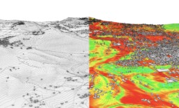
Computational Fluid Dynamics (CFD) supports the analysis of past (and present) microclimate in historical villages. A workflow based on Visual Programming Language (VPL) was developed to connect 3D geometrical modelling and CFD applications to accurately reproduce the behaviour of complex sites.
Elena Verticchio, Filippo Calcerano, Letizia Martinelli, Luciano Cessari, Elena Gigliarelli
Institute of Heritage Science - National Research Council
Michele Calvano
Sapienza Università di Roma
Index Volume 13
INDEX
Editorial
C. Bolognesi, M. Lo Turco
BIM-GIS Integration. A critical review
A. Bocca, A. M. Nese
Geospatial data and Visual Programming for BIM-GIS Modeling andd managemente of Hydropower Infrastructure
G. M. Ventura, F. M. Ugliotti, A. Osello
City Information Model for hydraulic risk management. A methodological approach.
A. Ganciu, E. Cicalò
Semi-automatic integration of GIS data into BIM environment for urban district modeling
A. Imperiale, F. M. Ugliotti, F. Matrone
Innovative strategies for planning the location of temporary dwellings in emergency situations.
D. D’Uva, F. Eugeni
BIM-GIS Integration for Risk Assessment of Built Heritage: Testing Recent Developments on Italian Public Buildings
E. Iacono, F.M. Ugliotti, A. Osello
Editorial Vol. 13
From the city to the building (and back): interoperable approaches between spatial information systems and BIM-based models
In recent years, the field of geographic information systems (GIS) has been strongly influenced by the evolution that the world of design is experiencing, with the shift from predominantly two-dimensional vector drawing to the Building Information Modeling (BIM) methodology. Graphical and numerical representations at the urban scale and the architectural representations have for a long time remained two separate entities for a long time, although they both refer to processes of digitizing data for the urban planning and the architectural design. In a world increasingly governed by interoperable logics and processes, it seems clear that an effective and efficient connection between these two worlds can bring about important evolutions in the field of the design, through the enhancement of data as a central element of the whole process. Moreover, we also witness the increasing possibility of using data from both urban and building scales intercepted by sensors and trackers, capable of revealing the operation and use both within a digitized existing and within a world still to be designed.
The information provided by GIS systems allows interventions to be prefigured at the urban scale, holding together a multiplicity of variables peculiar to the territorial and infrastructural system, reducing the number of errors especially in the preliminary and feasibility plan phase. On the other hand, project information, particularly those related to the actual implementation of the work, are of fundamental importance for updating GIS systems. In addition, reading data from the world of applied sensing adds additional variables and new possible uses.
On the direction of these different approaches leading back to the domains of the city or architecture and their mutual contamination, the different contributions are organized using common grounds of interchange increasingly aimed at the network, transferring the useful elements of the “design” from whatever source they come from within information systems of urban and territorial scale.
The experiments collected here are often aimed at the development of predictive strategies in terms of risk prevention, management of the existing, management of the operation of large public activities in existing buildings and new planning.
Specific themes to modeling activities \at any scale are mentioned in all of the research, i.e., the complexity of data exchange between different platforms or interoperability between several systems, modeling by nodes embedded in domains of object modeling, use of algorithms at different scales, management of databases or synchronously sensed data.
The experiments are anticipated by an essay on the state of the art of the BIM – GIS dialogue, which first denotes that this research domain is still in full development and particularly fertile for possible applications that are still too immature to be considered technically definitive.
That leaves at the moment applied research with all the solutions in fieri useful for determining lines of direction for transferring new skills, creating increasingly strong and structured connections between the academic world of research and the world of the profession.
Cecilia Bolognesi (Politecnico ddi Milano), Massimiliano Lo Turco. (Politecnico di Torino)
Semi-automatic integration of GIS data into BIM environment for urban district modeling
ABSTRACT
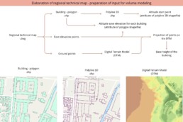
This research investigates a methodology for exchanging GIS-BIM data to generate urban portions through semi-automatic processes with visual programming.
Alessandra Imperiale, Francesca Maria Ugliotti, Francesca Matrone
Politecnico di Torino


